ZIPFIP is both a set of databases containing census and locational information organized by ZIP (ZIP code) and FIPS (county) levels, and a program by which these data sets may be accessed and manipulated. It has several useful features, including: editing and displaying data; defining spatial boundaries known as market areas; determining distances between any two sites in the lower 48 states; and aggregating observations. ZIPFIP can extract commonly used census information by county or ZIP code, and correct for missing values.
Many economic models are driven by spatially disaggregated data. For example, travel cost models require information on both the origin and the destination of visitors to a recreational site. Another example would be grain markets, where a model estimating shipping costs would require detail on the locations of grain silos and marketing centers. To facilitate the construction of such models, the Economic Research Service (with assistance from the Forest Service), developed the ZIPFIP software package.
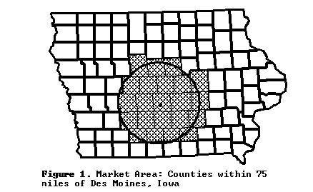
ZIPFIP can access and manipulate information by location. In particular, a key feature of ZIPFIP is its ability to create market area profiles. A market area is a geographic area whose boundaries are based on some measure of proximity, typical to some central location. For example, the market area illustrated in Figure I, "Counties within 75 miles of Des Moines, Iowa," is defined by a distance (75 miles) surrounding a central location (Des Moines). The profile of a market area is simply a table of information on each of the various "sub-regions" within the market area's boundaries. In the above example, the counties comprise the sub- regions. The market area profile can contain a wide variety of information, including latitude, longitude, place name, socio-economic information, climate data, and soil characteristics information.
This document outlines the capabilities of ZIPFIP. ZIPFIP users looking for technical details are referred to the ZIPFIP manual or to the on-line help included in the ZIPFIP program.
The ZIPFIP program and databases offer a simple, straightforward approach for using census and locational information. ZIPFIP has an easy-to-use, menu- driven look and feel -- plus plenty of available on-line help. ZIPFIP provides a selection of variables available from a variety of more complete databases, such as those available directly from the U.S. Census. In addition, the ZIPFIP program provides several data processing routines useful for manipulating this data. Because ZIPFIP relies on secondary sources for its data and cannot guarantee accuracy of each data point, its strengths lie in bulk processing of a limited amount of information for a quantity of zones (ZIP or FIPS). ZIPFIP would be less appropriate for detail on a single county or ZIP code.
One of this program's most attractive functions is its ability to create market area profiles. A market area might be defined as a list of zones (indicated by ZIP or FIPS codes) within a specified proximity of a selected center, or as a set of such lists, one for each of several sites. Thus, the user can tailor a market area profile to suit her/his research needs.
Among its disadvantages, ZIPFIP may not match the user friendliness of more sophisticated commercial products. Its interface is more old-fashioned and has less of a "windows" orientation. Also, due to cost constraints, ZIPFIP cannot guarantee the accuracy of each data point available in its databases. If the user requires less commonly used variables, s/he may not find them in ZIPFIP and will need to go directly to the secondary source. Once again, ZIPFIP would be less appropriate for detail on a single county or ZIP code.
A variety of databases are available for use with ZIPFIP. They contain commonly used information gathered from secondary sources of data. ZIPFIP databases include:
ZIPFIP provides a number of data processing features, divisible into several categories:
In addition to this, ZIPFIP incorporates heuristics for cases where data is missing. For example, missing values occur frequently in ZIP data, due to small samples and to "non-existent" ZIP codes. Corrective actions for ZIP data include:
(a) Using FIPS measures for missing values in the ZIP data; and
(b) Scaling the ZIP population variable to account for changes in ZIP code boundaries since the 1980 census.
ZIPFIP also has some very helpful functions for the general user. For example, the function PRINTSTATS will produce an output file of census information relevant to the zone(s) selected by the user. ZIPFIP makes available 42 variables alone from its ZIPFIP-1990 database, giving statistical information on, for example, population, income, voting preferences, and education. For several of these variables (such as population and per capita income), time series information from 1969 to 1990 is available at the county level. In addition, PRINTSTATS can deal with cancelled ZIP codes (a common problem given the transient nature of ZIP code boundaries) and missing values in a data set. Unlocated ZIP codes may be replaced with numerically close substitutes or left blank. Missing values, when ZIP- code information is requested, can be partially solved by using the value of the same variable from the appropriate FIPS code.
Another feature of ZIPFIP is TRIPDIST and COMPDIST. TRIPDIST computes the minimum possible mileage for a multiple (maximum of 5) stop trip by optimizing until it finds the route with the least mileage. COMPDIST, on the other hand, computes the distance of a trip in the exact order in which the sites are listed.
You can